Flevopark via the Ringdijk Walk
Flevopark via the Ringdijk Walk
7.5 miles / 12 kilometers
The Dutch reclaimed much of the land they live on; you can see what this means in parts of Amsterdam. While you walk to Flevopark, you will pass through Watergraafsmeer, which was once a lake (meer). You’ll walk on the Ringdijk where the water beside you is at a higher level than the land (which has been reclaimed) below, and which is now occupied by streets and houses, parks and allotments.
Flevopark via the Ringdijk Walk in Amsterdam (follow link to see in Google maps)
Flevo is the Roman name for the IJsselmeer (previously known as the Zuiderzee), it’s that huge body of water that sits in the middle of The Netherlands. The position of Flevopark accounts for its name – so have a look at the map.
This satisfying walk offers a variety of scenery, architecture and atmosphere. It is a non-touristic route and will take you in and out of lots of different parts of Amsterdam. It’s best done on a reasonably nice day as there are some longish stretches where you’re exposed to the elements.
Start either in the centre somewhere on the Amstel (see map) or join nearer the Ringdijk if that suits you better.
Route in brief
First you leave town and walk south beside the Amstel river. Then our route branches off eastwards over the Ringdijk towards Flevopark. From the park you return westwards to central Amsterdam through some nice (and less nice) suburbs. You can take a tram (e.g. 7 or 14) back to town from near Flevopark if you want.
After walking south along the Weesperzijde, you’ll turn left (east) at Schollenbrugstraat - go under railway tunnel and continue along to the traffic lights on the Wibautstraat to get you on to the Ringvaart waterside path ahead. Look back at the big silhouettes of camels above on the railway bridge – a great sight especially if the sun is in the west and behind the silhouettes.
Continue along the Ringvaart after crossing the busy Wibautstraat at the traffic lights.
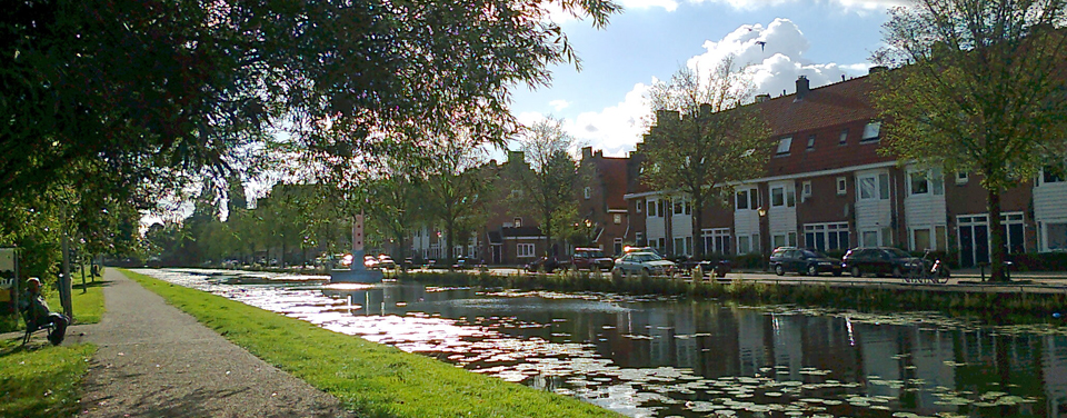
The Ringvaart
The footpath is right beside the water going east. It’s a lovely, long and tranquil path stretching into the distance; it’s grassy and tree-lined, and there are lots of birds around and in the water. Some benches too should you wish to picnic or just sit and stare.
Here on the Ringvaart, you get a perfect view of a polder. You have the water a few metres beside you while the land and houses are way below - the water is at a much higher level! If this concept has always confounded you or if you haven’t the slightest notion what I’m talking about, then you should certainly do this walk! Once you see it, you will get it.
Watergraafsmeer
This polder to your right is called the Watergraafsmeer - the land here was reclaimed in 1629 – before that it was a lake. That’s what a polder is: land is reclaimed; water is dredged out and re-routed. You may remember all of this from geography class? Watergraafsmeer is one of the lowest lying parts of Amsterdam.
You’ll walk through a part of Watergraafsmeer, but if you have time, there is plenty more to explore – check out the Linnaeushof for instance. Watergraafsmeer is full of nice architecture, attractive residential streets and stately buildings, nice trees and pavement gardens but also nice shops and cafés. It’s a real neighbourhood. It’s very easy to re-join the route to Flevopark.
Flevopark
Work begun on the park in 1928 and it was the idea of the naturalist Jac P. Thijsse* to whom The Netherlands can be very grateful. The Flevopark derives from the Flevomeer which was the previous name of the Zuiderzee which we now call the IJsselmeer. It is the huge expanse of water which stretches north from Amsterdam to the Frisian Islands and the North Sea. When that body of water was cut off from the open sea, by the construction of the Afsluitdijk (causeway), it was renamed the IJsselmeer (referring to the change from a sea to a lake). The Afsluitdijk dam is 32 km long – no mean feat in 1932, when construction was completed. It provides a two-lane causeway connection between North Holland and Friesland and, of course, it functions as a dam, preventing flooding in the country. Flevo goes back to Roman times and was the Roman name for that body of water. All quite interesting, Roman connections always are – and they’re worth a bit of long-windedness ; )
Anyway, the Flevopark is a nice, spacious park with plenty of interesting trees, water, and colourful shrubs (rhododendron etc) in spring. This eastern perimeter of the city has many interesting sides to it and it is peaceful too.
Flevopark back to town
After the Flevopark, you can follow our route back into the centre, or you can follow part of it, or, if you don’t fancy walking through the suburbs, you can hop on Tram 7 or 14 to get you back into the centre.
There are plenty cafés, pubs and restaurants near Javaplein if you’re feeling tired and thirsty. This part of Amsterdam is called the East Indies district and you’ll see this in the street names.
If you do decide to walk the entire route, there are rewarding green gems like the Zeeburgerdijk, Louise Wentstraat, Sarphatistraat (Artis side) but there are also long and boring stretches beside biggish roads, under railway bridges etcetera.
All in a good cause, that’s how I look at it - and there is always something to see if you’re in a positive frame of mind. This round-trip will acquaint you with a less touristic side of Amsterdam.
*J P Thijsse founded the Dutch version of the National Trust – for preservation of the Dutch Natural Heritage
| good time for this walk | spring | summer | autumn | winter |
|---|
| area of walk | north | |
|---|---|---|
| west | centre | east |
| south |